


10 year collaboration secures long term flood protection for Leeds

Project overview
Engineering firsts deliver 1 in 200-year flood protection
Over the decade-long project Mott MacDonald worked in joint venture with Bam Nuttall as BMM to deliver the £200M scheme for Leeds City Council (LCC) with its technical advisor Aecom and stakeholders, including the Environment Agency and Network Rail. Mott MacDonald supported the Environment Agency with of UK’s largest ever natural flood management project, while BMM built the country’s first mechanically lowering weirs for flood alleviation.
The completion provides 1 in 200 year flood protection for over 4,000 homes and almost 1,000 businesses through to 2069. The impact is wider than flood protection though, with the project expected to result in regeneration benefits of £774M over 10 years and creation of approximately 3,000 additional jobs.

Maximising the flood protection benefits
The origin for the need for new flood defences in Leeds dates back to 2000 with initial ideas drawn up by the Environment Agency following near-miss flood events in 2000 and 2007. The scheme proposed in 2010 relied on a mix of high flood defence walls, which effectively cut off the city from the river, and a large upstream barrier. However, there was no firm timeline or funding guaranteed to progress that work.
BMM was contracted by LCC in 2014 to further develop an outline design for a project focused on the section of the river downstream from Leeds station under a £50M design and build contract.
4,000 homes and 1,000 businesses protected by both phases of Leeds Flood Alleviation Scheme
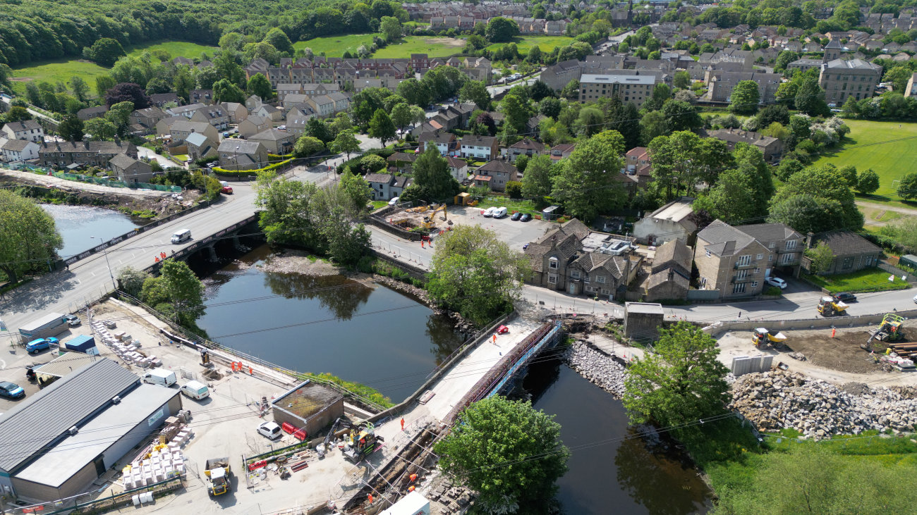
“The focus of this first phase was to remove any obstacles in the river channel with two mechanically lowering weirs that created a larger channel during high flows, merging the river and canal at one point and constructing 4.5km of flood walls and embankments,” explains Mott MacDonald design manager Peter Charlesworth.
The weir design, which was developed by Arup but delivered by BMM, was key to reducing the height of the previously planned flood walls in the city by 1.2m. BMM also worked to incorporate the flood walls into existing structures and new public realm or, where that was not possible, the visual impact was minimised by including glazed panels in the defences. The resulting flood defences, which brought flood protection for the city up to a 1 in 100-year level, have been described as “invisible” as a result.
Development of the second phase of the scheme called for wider collaboration and saw BMM joining forces with Arup and flood modelling specialist Thomas MacKay to undertake the feasibility work.
This collaborative development stage took a whole catchment approach to managing the flood risk from the River Aire. This resulted in Mott MacDonald and Bam Nuttall working with LCC to put together a business case to bring forward work that had been expected to fall into a later phase to maximise the benefits and deliver 1 in 200-year protection. This work saw creation of a major flood storage facility upstream to impound 1.8Mm3 water at times of peak flow and allow it to be released downstream in a controlled manner.
Phase two on the Leeds FAS also included construction of 8km of linear defences over a 14km length of the river, control structures on three goits, three pumping stations, the removal of two bridges that obstructed high flows.
Working with the Environment Agency, Mott MacDonald also provided advice on deployment of natural flood management techniques in the upper catchment of the River Aire as part of the second phase. This work was critical to extending the timespan of the 1 in 200-year protection of the overall scheme from 2039 through to 2069.
Collaboration key to putting innovation into action
Bringing together a number of UK firsts, in combination with delivery of the major flood storage scheme at Calverley, are all essential elements for the Leeds FAS project. However, the collaborative approach to the overall project was critical to the delivery of these innovations, as well as stakeholder management to overcome site challenges.
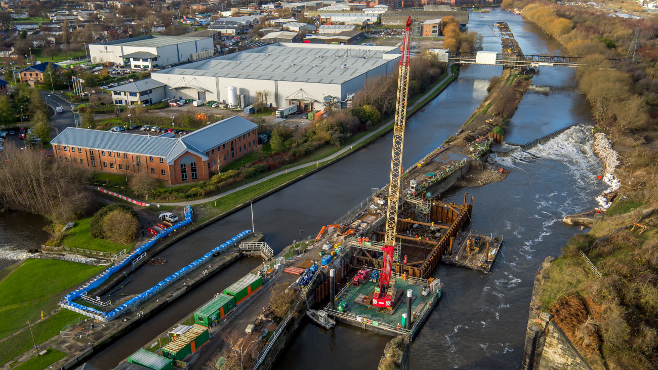
In phase one, the key issue was taking the mechanical weirs from concept to construction and operation. Planning how to build the weirs at Knostrop and Crown Point was difficult beyond it being the first time the technology had been used in the UK. “The new structures were replacing existing fixed weirs at the same locations, and we needed to maintain the flow throughout construction for navigation,” explains Bam Nuttall project director Andy Judson.
BMM used cofferdams to undertake the installation with piling rigs and cranes on pontoons at Knostrop and equipment lifted into position on an existing island at Crown Point.
The weirs, which were built to Arup’s design by mechanical engineering firm Obermeyer, are supported by inflatable neoprene bladders that can be lowered when high river flows are expected.
Apart from the lowering capabilities, the new weirs also allowed fish passes to be built, removing an obstruction created by the previous Victorian-era structures. Following completion, otters and salmon were spotted upstream of Knostrop for the first time in 200 years, demonstrating biodiversity improvement of the river.
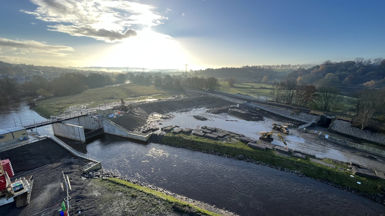
In the second phase, the main engineering challenge was construction of the flood embankment dam for the new Calverley Reservoir. The 200m long, 6.2m high earth embankment, which was formed using material from an on-site borrow pit was built across the natural flood plain. Automatic steel sluice gates, which are controlled on a minute-by-minute basis by water levels downstream of the dam, enable the flood plain area to hold water at a greater depth than would naturally be possible.
“The aim is to raise the gates as late as possible to make the best use of the storage and then lower them as soon as possible too,” says Peter.
The final part of the scheme to be completed was the natural flood management which features leaky dams, river meanders, planting of over 750,000 trees and aeration of 1,240ha of soil. In combination, these features reduce peak flows by 5% and will remove 18m3/s from the flow, reducing pressure lower down the catchment.
Peter adds: “Without the natural flood management, the floodwalls downstream would have needed to be 100mm to 200mm higher to give the same protection. When that is put in context of the 8km of flood walls within the second phase, the natural flood management has a major impact on reducing the embodied carbon of the work.”
10 years of work delivers safeguarding for 40 years
The first phase of Leeds FAS was completed in 2017 offering 1 in 100-year flood protection to 3,000 homes and 500 businesses. However, the combination of conventional hard engineering solutions and natural flood management was central to extending that protection against 1 in 200-year flood risk through to 2069. The work on the second phase also saw that 1 in 200-year protection extended to a further 1,048 homes and 474 businesses.
LCC has estimated that, as well as protecting existing businesses and homes, the work will lead to regeneration benefits of £774M over 10 years and creation of approximately 3,000 additional net jobs.
45,130tCO2e - carbon cost of the work, compared to 51,670tCO2e carbon cost of Storm Eva clear up
Carbon analysis of the Leeds FAS work, alongside the carbon cost of the clearing up following Storm Eva on Boxing Day 2015 which impacted phase one and triggered 4,712 flood incidents in Leeds, demonstrates the benefits of the work. In addition to Storm Eva causing a £500M impact on the city region, including £37M in direct damage, the University of Edinburgh has found that the carbon cost of the clean up was 51,670tCO2e. This compares to the university’s calculations for the carbon cost of the FAS work which was 45,130tCO2e. Protecting the city from a single flood event of that scale will deliver a carbon saving of 6,540tCO2e and those savings will continue to accrue through to 2069.
LCC project manager Mark Garford adds that reducing flooding is crucial to tackling the climate emergency: “The carbon cost of clearing up after a flood is significant, so the construction of hard engineered defences can be seen as an investment towards our 2030 carbon neutral target. Climate change will bring higher river levels over time, eroding the effectiveness of built defences.
"Due to economic, environmental and community impacts, walls can only be built to a certain height, so using those combined with natural flood management techniques is the best and most sustainable solution.”
In addition to reducing the risk of financial costs and carbon costs associated with major flood clean up over the next 45 years, the work itself has been recognised for the environmental standard set during delivery. Following completion, the scheme achieved an “Excellent” rating under the BREEAM science-based sustainability assessment, with maximum scores in the communities and stakeholders, resilience and pollution categories.


Subscribe for exclusive updates
Receive our expert insights on issues that transform business, increase sustainability and improve lives.